Ville de Harmony (Indiana)
Informations
Chiffres
- Code pays :
- US
- Code postal :
- 47853
- Latitude :
- 39.57741
- Longitude :
- -87.05744
- Zone horaire :
- America/Indiana/Indianapolis
- Fuseau horaire :
- UTC-5
- Heure d'été :
- Y
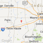
La ville de Harmony appartient à l'état Indiana et au comté Clay.
La ville de Harmony s'étend sur 1,93 km² et compte 656 habitants (recensement de 2010) pour une densité de 339,90 habitants par km². L'altitude moyenne est de 205 m.
Le nom espagnol est Harmony.
Le site Internet de Harmony est http://www.census.gov
©photo-libre.fr