Ville de Steckborn (Thurgovie)
Informations
Chiffres
- Code pays :
- CH
- Code postal :
- 8266
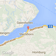
- Latitude :
- 47.66802
- Longitude :
- 8.98231
- Zone horaire :
- Europe/Zurich
- Fuseau horaire :
- UTC+1
- Heure d'été :
- Y
La ville de Steckborn appartient au canton Thurgovie, au district Steckborn et à l'arrondissement Steckborn.
La ville de Steckborn s'étend sur 8,76 km² et compte 3 435 habitants pour une densité de 392,12 habitants par km². L'altitude maximum est de 400 m, l'altitude moyenne est de 400 m.
La langue officiel de la ville est Allemand. Le nom français de la ville est Steckborn, le nom anglais de la ville est Steckborn, le nom espagnol est Steckborn.
Le site Internet de Steckborn est http://www.steckborn.ch
©photo-libre.fr