Ville de Portadown (Northern Ireland)
Informations
Chiffres
- Code pays :
- GB
- Code postal :
- BT62
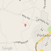
- Latitude :
- 54.42774
- Longitude :
- -6.47657
- Zone horaire :
- Europe/London
- Fuseau horaire :
- UTC
- Heure d'été :
- Y
La ville de Portadown appartient à la nation Northern Ireland et au comté Craigavon.
La ville de Portadown compte 20 001 habitants (recensement de 2001). L'altitude moyenne est de 80 m.
Le nom français de la ville est Portadown.
Le site Internet de Portadown est http://www.portadowntown.com
©photo-libre.fr