Ville de Craigavon (Northern Ireland)
Informations
Chiffres
- Code pays :
- GB
- Code postal :
- BT62
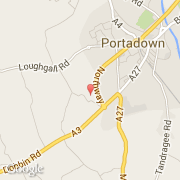
- Latitude :
- 54.41125
- Longitude :
- -6.46606
- Zone horaire :
- Europe/London
- Fuseau horaire :
- UTC
- Heure d'été :
- Y
La ville de Craigavon appartient à la nation Northern Ireland et au comté Craigavon.
La ville de Craigavon s'étend sur 115 km² et compte 1 200 habitants (recensement de 1999) pour une densité de 10,43 habitants par km².
(D.U.P.).
Le nom français de la ville est Craigavon.
La devise de Craigavon est "Pro Tanto Quid Retribuamus". Le site Internet de Craigavon est http://www.armagh.gov.uk
©photo-libre.fr