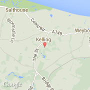
La ville de Kelling appartient à la nation England, au comté Norfolk et au district North Norfolk.
La ville de Kelling s'étend sur 8,06 km² et compte 175 habitants (recensement de 2001) pour une densité de 21,71 habitants par km². Le nom français de la ville est Kelling.
La ville de Kelling appartient à la nation England, au comté Norfolk et au district North Norfolk.
La ville de Kelling s'étend sur 8,06 km² et compte 175 habitants (recensement de 2001) pour une densité de 21,71 habitants par km². Le nom français de la ville est Kelling.