Ville de Union (Ohio)
Informations
Chiffres
- Code pays :
- US
- Code postal :
- 45322
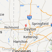
- Latitude :
- 39.88404
- Longitude :
- -84.34680
- Zone horaire :
- America/New_York
- Fuseau horaire :
- UTC-5
- Heure d'été :
- Y
La ville de Union appartient à l'état Ohio et au comté Montgomery.
La ville de Union s'étend sur 18,46 km² et compte 6 419 habitants (recensement de 2010) pour une densité de 347,72 habitants par km². L'altitude moyenne est de 247 m.
Le maire de la ville de Union est actuellement Michael O'Callaghan.
Le nom espagnol est Union.
La ville de Union a été fondée en 1806. Le site Internet de Union est http://www.ci.union.oh.us
©photo-libre.fr