Ville de Union City (Indiana)
Informations
Chiffres
- Code pays :
- US
- Code postal :
- 47390
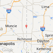
- Latitude :
- 40.20338
- Longitude :
- -84.81786
- Zone horaire :
- America/Indiana/Indianapolis
- Fuseau horaire :
- UTC-5
- Heure d'été :
- Y
La ville de Union City appartient à l'état Indiana et au comté Randolph.
La ville de Union City s'étend sur 5,72 km² et compte 3 584 habitants (recensement de 2010) pour une densité de 626,57 habitants par km². L'altitude moyenne est de 336 m.
Le maire de la ville de Union City est actuellement Bryan K. Conklin.
Le nom espagnol est Union City.
Le site Internet de Union City est http://www.census.gov
©photo-libre.fr