Ville de Harth-Pöllnitz (Thüringen)
Informations
Chiffres
- Code pays :
- DE
- Code postal :
- 07570
- Latitude :
- 50.75473
- Longitude :
- 11.95819
- Zone horaire :
- Europe/Berlin
- Fuseau horaire :
- UTC+1
- Heure d'été :
- Y
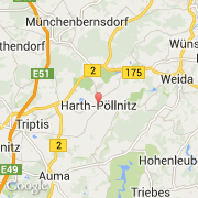
La ville de Harth-Pöllnitz appartient à l'état Thüringen et au district Greiz.
La ville de Harth-Pöllnitz s'étend sur 55,36 km² et compte 3 284 habitants pour une densité de 59,32 habitants par km². L'altitude moyenne est de 320 m.
Le bourgemestre de la ville de Harth-Pöllnitz est actuellement Bernhard Waldert (CDU).
Le site Internet de Harth-Pöllnitz est http://www.harth-poellnitz.de
©photo-libre.fr