Ville de Wingate (England)
Informations
Chiffres
- Code pays :
- GB
- Code postal :
- TS28
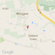
- Latitude :
- 54.72517
- Longitude :
- -1.37624
- Zone horaire :
- Europe/London
- Fuseau horaire :
- UTC
- Heure d'été :
- Y
La ville de Wingate appartient à la nation England, au comté Durham et au district Sedgefield.
La ville de Wingate s'étend sur 4,4 km² et compte 3 491 habitants (recensement de 2010) pour une densité de 793,41 habitants par km². L'altitude moyenne est de 179 m.
Le maire est John Quinn.
Le nom espagnol est Wingate.
©photo-libre.fr