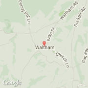
Ville de Waltham (England)
Informations
Chiffres
- Code pays :
- GB
- Code postal :
- CT4
- Latitude :
- 51.19834
- Longitude :
- 1.01555
- Zone horaire :
- Europe/London
- Fuseau horaire :
- UTC
- Heure d'été :
- Y
La ville de Waltham appartient à la nation England, au comté Kent et au district Canterbury.
La ville de Waltham s'étend sur 35,62 km² et compte 60 632 habitants (recensement de 2010) pour une densité de 1 702,19 habitants par km². L'altitude moyenne est de 26 m.
Le nom espagnol est Waltham.
Le site Internet de Waltham est http://www.city.waltham.ma.us
©photo-libre.fr