Ville de Tenterden (England)
Informations
Chiffres
- Code pays :
- GB
- Code postal :
- TN30
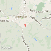
- Latitude :
- 51.06135
- Longitude :
- 0.69585
- Zone horaire :
- Europe/London
- Fuseau horaire :
- UTC
- Heure d'été :
- Y
La ville de Tenterden appartient à la nation England, au comté Kent et au district Ashford.
La ville de Tenterden s'étend sur 36,19 km² et compte 7 613 habitants (recensement de 2001) pour une densité de 210,36 habitants par km².
Le nom espagnol est Tenterden.
Le site Internet de Tenterden est http://www.tenterdentown.co.uk
©photo-libre.fr