Ville de Stanton (England)
Informations
Chiffres
- Code pays :
- GB
- Code postal :
- DE15
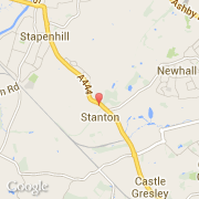
- Latitude :
- 52.77628
- Longitude :
- -1.60347
- Zone horaire :
- Europe/London
- Fuseau horaire :
- UTC
- Heure d'été :
- Y
La ville de Stanton appartient à la nation England, au comté Derbyshire et au district South Derbyshire.
La ville de Stanton s'étend sur 1,23 km² et compte 366 habitants (recensement de 2010) pour une densité de 297,56 habitants par km². L'altitude moyenne est de 519 m.
Le nom espagnol est Stanton.
©photo-libre.fr