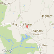
Ville de Stalham (England)
Informations
Chiffres
- Code pays :
- GB
- Code postal :
- NR12
- Latitude :
- 52.77097
- Longitude :
- 1.51729
- Zone horaire :
- Europe/London
- Fuseau horaire :
- UTC
- Heure d'été :
- Y
Informations
Chiffres
Villes voisines
Les transports de Stalham
Informations
Chiffres
Villes voisines
Les transports de Stalham