Ville de Manningtree (England)
Informations
Chiffres
- Code pays :
- GB
- Code postal :
- CO11
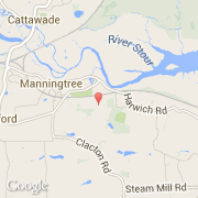
- Latitude :
- 51.94117
- Longitude :
- 1.07691
- Zone horaire :
- Europe/London
- Fuseau horaire :
- UTC
- Heure d'été :
- Y
La ville de Manningtree appartient à la nation England, au comté Suffolk et au district Babergh.
La ville de Manningtree compte 900 habitants.
Le site Internet de Manningtree est http://www.neighbourhood.statistics.gov.uk
©photo-libre.fr