Ville de Hentland (England)
Informations
Chiffres
- Code pays :
- GB
- Code postal :
- HR9
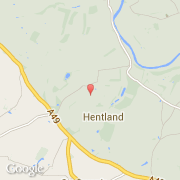
- Latitude :
- 51.93930
- Longitude :
- -2.66958
- Zone horaire :
- Europe/London
- Fuseau horaire :
- UTC
- Heure d'été :
- Y
La ville de Hentland appartient à la nation England et au comté Herefordshire.
La ville de Hentland compte 443 habitants.
Le site Internet de Hentland est http://neighbourhood.statistics.gov.uk
©photo-libre.fr