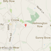
Ville de Crook (England)

royaume-uni

Informations

Chiffres

Code pays :
GB
Code postal :
DL15
Latitude :
54.71019
Longitude :
-1.73099
Zone horaire :
Europe/London
Fuseau horaire :
UTC
Heure d'été :
Y

La ville de Crook appartient à la nation England, au comté Durham et au district Wear Valley.

Villes voisines

  • Helmington Row ~1 km
  • North Bitchburn ~2 km
  • Greenhead ~2 km
  • Howden le Wear ~2 km
  • Billy Row ~3 km
  • Stanley ~3 km
  • Sunnybrow ~2 km
  • Hunwick ~3 km
  • Wear Valley Junction ~3 km

Les transports de Crook

Aéroport international
Newcastle ~37 km
Autres transports
Newcastle Railway Station ~30 km
Leeming ~48 km
Booking.com

Rejoignez-nous !

Vous aimez ? Partagez !