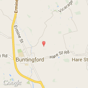
Ville de Buntingford (England)
Informations
Chiffres
- Code pays :
- GB
- Code postal :
- SG9
- Latitude :
- 51.95163
- Longitude :
- -0.00864
- Zone horaire :
- Europe/London
- Fuseau horaire :
- UTC
- Heure d'été :
- Y
La ville de Buntingford appartient à la nation England, au comté Hertfordshire et au district North Hertfordshire.
La ville de Buntingford s'étend sur 5,93 km² et compte 4 820 habitants (recensement de 2001) pour une densité de 812,82 habitants par km².
Le nom espagnol est Buntingford.
©photo-libre.fr