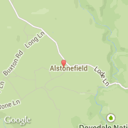
Ville de Alstonefield (England)
Informations
Chiffres
- Code pays :
- GB
- Code postal :
- DE6
- Latitude :
- 53.09704
- Longitude :
- -1.80901
- Zone horaire :
- Europe/London
- Fuseau horaire :
- UTC
- Heure d'été :
- Y
La ville de Alstonefield appartient à la nation England, au comté Staffordshire et au district Staffordshire Moorlands.
La ville de Alstonefield s'étend sur 14,28 km² et compte 274 habitants (recensement de 2001) pour une densité de 19,19 habitants par km².
Le nom espagnol est Alstonefield.
©photo-libre.fr