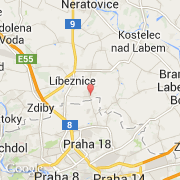
Ville de Hovorčovice (Hlavní město Praha)

republique-tcheque

Informations

Chiffres

Code pays :
CZ
Code postal :
250-64
Latitude :
50.17874
Longitude :
14.51897
Zone horaire :
Europe/Prague
Fuseau horaire :
UTC+1
Heure d'été :
Y

La ville de Hovorčovice appartient à la région Hlavní město Praha, au district Praha-východ et à la commune Měšice u Prahy.

La ville de Hovorčovice compte 2 005 habitants (recensement de 2010). L'altitude moyenne est de 226 m.
Le nom anglais de la ville est Hovorčovice.

Villes voisines

  • Měšice ~2 km
  • Líbeznice ~2 km
  • Veleň ~3 km
  • Zlonín ~4 km
  • Mratín ~4 km
  • Bořanovice ~3 km
  • Sluhy ~3 km
  • Nová Ves ~5 km
  • Bašť ~4 km

Les transports de Hovorčovice

Aéroport international
Ruzyne ~20 km
Autres transports
Kbely ~7 km
Florenc Central Bus Station ~11 km
Praha hlavni nadrazi ~12 km
Vodochody ~10 km
Sazena ~26 km
Booking.com

Rejoignez-nous !

Vous aimez ? Partagez !