Ville de Port Tobacco (Maryland)
Informations
Chiffres
- Code pays :
- US
- Code postal :
- 20677
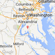
- Latitude :
- 38.50835
- Longitude :
- -77.04238
- Zone horaire :
- America/New_York
- Fuseau horaire :
- UTC-5
- Heure d'été :
- Y
La ville de Port Tobacco appartient à l'état Maryland et au comté Charles.
La ville de Port Tobacco s'étend sur 0,41 km².
Le site Internet de Port Tobacco est http://www.census.gov
©photo-libre.fr