Ville de Highland Park (New Jersey)
Informations
Chiffres
- Code pays :
- US
- Code postal :
- 08904
- Latitude :
- 40.50060
- Longitude :
- -74.42712
- Zone horaire :
- America/New_York
- Fuseau horaire :
- UTC-5
- Heure d'été :
- Y
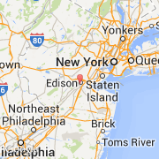
La ville de Highland Park appartient à l'état New Jersey et au comté Middlesex.
La ville de Highland Park s'étend sur 4,712 km² et compte 13 982 habitants (recensement de 2010) pour une densité de 2 967,32 habitants par km².
Le maire de la ville de Highland Park est actuellement Gary Minkoff.
Le nom français de la ville est Highland Park.
La ville de Highland Park a été fondée en 1905. Le site Internet de Highland Park est http://hpboro.com
©photo-libre.fr