Ville de Glendora (New Jersey)
Informations
Chiffres
- Code pays :
- US
- Code postal :
- 08029
- Latitude :
- 39.83950
- Longitude :
- -75.06748
- Zone horaire :
- America/New_York
- Fuseau horaire :
- UTC-5
- Heure d'été :
- Y
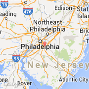
La ville de Glendora appartient à l'état New Jersey et au comté Camden.
La ville de Glendora s'étend sur 2,751 km² et compte 4 750 habitants (recensement de 2010) pour une densité de 1 726,64 habitants par km². L'altitude moyenne est de 24 m.
©photo-libre.fr