Ville de Dorothy (New Jersey)
Informations
Chiffres
- Code pays :
- US
- Code postal :
- 08317
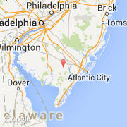
- Latitude :
- 39.40780
- Longitude :
- -74.81892
- Zone horaire :
- America/New_York
- Fuseau horaire :
- UTC-5
- Heure d'été :
- Y
La ville de Dorothy appartient à l'état New Jersey et au comté Atlantic.
©photo-libre.fr