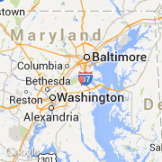
Ville de Crofton (Maryland)
Informations
Chiffres
- Code pays :
- US
- Code postal :
- 21114
- Latitude :
- 39.00733
- Longitude :
- -76.68268
- Zone horaire :
- America/New_York
- Fuseau horaire :
- UTC-5
- Heure d'été :
- Y
La ville de Crofton appartient à l'état Maryland et au comté Anne Arundel.
La ville de Crofton s'étend sur 13,0 km² et compte 2 500 habitants (recensement de 2010) pour une densité de 192,31 habitants par km². L'altitude moyenne est de 30 m.
Le nom français de la ville est Crofton.
Le site Internet de Crofton est http://factfinder2.census.gov
©photo-libre.fr