Ville de Capitol Heights (Maryland)
Informations
Chiffres
- Code pays :
- US
- Code postal :
- 20731
- Latitude :
- 38.88439
- Longitude :
- -76.91173
- Zone horaire :
- America/New_York
- Fuseau horaire :
- UTC-5
- Heure d'été :
- Y
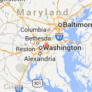
La ville de Capitol Heights appartient à l'état Maryland et au comté Prince Georges.
La ville de Capitol Heights s'étend sur 2,07 km² et compte 4 337 habitants (recensement de 2010) pour une densité de 2 095,17 habitants par km². L'altitude moyenne est de 60 m.
Le nom espagnol est Capitol Heights.
©photo-libre.fr