Ville de Waratah (New South Wales)
Informations
Chiffres
- Code pays :
- AU
- Code postal :
- 2298
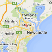
- Latitude :
- -32.90815
- Longitude :
- 151.72722
- Zone horaire :
- Australia/Sydney
- Fuseau horaire :
- UTC+10
- Heure d'été :
- Y
La ville de Waratah appartient à l'état New South Wales et à la région Hunter.
La ville de Waratah s'étend sur 1,9 km² et compte 4 760 habitants pour une densité de 2 505,26 habitants par km².
Le nom anglais de la ville est Waratah.
©photo-libre.fr