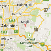
Ville de Stonyfell (South Australia)
Informations
Chiffres
- Code pays :
- AU
- Code postal :
- 5066
- Latitude :
- -34.93488
- Longitude :
- 138.67763
- Zone horaire :
- Australia/Adelaide
- Fuseau horaire :
- UTC+9:30
- Heure d'été :
- Y
La ville de Stonyfell appartient à l'état South Australia et à la région SA Subs Near 1.
La ville de Stonyfell compte 1 326 habitants.
Le nom anglais de la ville est Stonyfell.
©photo-libre.fr