Ville de Lysterfield (Victoria)
Informations
Chiffres
- Code pays :
- AU
- Code postal :
- 3156
- Latitude :
- -37.92260
- Longitude :
- 145.28208
- Zone horaire :
- Australia/Melbourne
- Fuseau horaire :
- UTC+10
- Heure d'été :
- Y
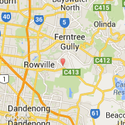
La ville de Lysterfield appartient à l'état Victoria et à la région Ferntree Gully.
La ville de Lysterfield s'étend sur 2,1 km² et compte 5 423 habitants pour une densité de 2 582,38 habitants par km².
Le nom anglais de la ville est Lysterfield.
©photo-libre.fr