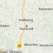
Ville de Rattiszell (Bayern)
Informations
Chiffres
- Code pays :
- DE
- Code postal :
- 94372
- Latitude :
- 49.02596
- Longitude :
- 12.65944
- Zone horaire :
- Europe/Berlin
- Fuseau horaire :
- UTC+1
- Heure d'été :
- Y
La ville de Rattiszell appartient à l'état Bayern, au comté Niederbayern et au district Straubing-Bogen.
La ville de Rattiszell s'étend sur 22,16 km². L'altitude moyenne est de 363 m.
Le bourgemestre de la ville de Rattiszell est actuellement Josef Schneider.
Le nom français de la ville est Rattiszell.
Le site Internet de Rattiszell est http://www.vg-stallwang.de
©photo-libre.fr