Ville de Krugsdorf (Mecklenburg-Vorpommern)
Informations
Chiffres
- Code pays :
- DE
- Code postal :
- 17309
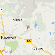
- Latitude :
- 53.52478
- Longitude :
- 14.08353
- Zone horaire :
- Europe/Berlin
- Fuseau horaire :
- UTC+1
- Heure d'été :
- Y
La ville de Krugsdorf appartient à l'état Mecklenburg-Vorpommern et au district Uecker-Randow.
La ville de Krugsdorf s'étend sur 8,34 km² et compte 426 habitants pour une densité de 51,08 habitants par km². L'altitude moyenne est de 17 m.
Le site Internet de Krugsdorf est http://www.amt-uecker-randow-tal.de
©photo-libre.fr