Ville de Kemnath (Bayern)
Informations
Chiffres
- Code pays :
- DE
- Code postal :
- 95478
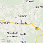
- Latitude :
- 49.87076
- Longitude :
- 11.89071
- Zone horaire :
- Europe/Berlin
- Fuseau horaire :
- UTC+1
- Heure d'été :
- Y
La ville de Kemnath appartient à l'état Bayern, au comté Oberpfalz et au district Tirschenreuth.
La ville de Kemnath s'étend sur 54,13 km² et compte 5 285 habitants pour une densité de 97,64 habitants par km². L'altitude moyenne est de 462 m.
Le bourgemestre de la ville de Kemnath est actuellement Werner Nickl.
Le nom français de la ville est Kemnath.
Le site Internet de Kemnath est http://www.kemnath.de
©photo-libre.fr