Ville de Blankenfelde (Brandenburg)
Informations
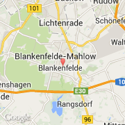
Chiffres
- Code pays :
- DE
- Code postal :
- 15827
- Latitude :
- 52.33686
- Longitude :
- 13.41445
- Zone horaire :
- Europe/Berlin
- Fuseau horaire :
- UTC+1
- Heure d'été :
- Y
La ville de Blankenfelde appartient à l'état Brandenburg et au district Teltow-Fläming.
La ville de Blankenfelde s'étend sur 13,4 km² et compte 1 917 habitants (recensement de 2008) pour une densité de 143,06 habitants par km².
Le nom anglais de la ville est Blankenfelde.
©photo-libre.fr